


LE BOIS D'OINGT - Les pierres dorées

AndreLACOMBE
User

Length
10.7 km

Max alt
585 m

Uphill gradient
415 m
Km-Effort
16.2 km

Min alt
332 m

Downhill gradient
408 m
Boucle
Yes
Creation date :
2023-05-29 08:10:04.236
Updated on :
2023-05-29 08:12:46.274
3h40
Difficulty : Easy

FREE GPS app for hiking
 SityTrail
IGN / Geographical institutes
SityTrail Plus
The world is yours!
About
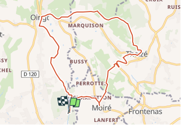
Trail On foot of 10.7 km to be discovered at Auvergne-Rhône-Alpes, Rhône, Val d'Oingt. This trail is proposed by AndreLACOMBE.
Description
Parking du lac de Nizy - Travesée de Oingt, puis Theizé et Moiré. Retour parking.
Positioning
Country:
France
Region :
Auvergne-Rhône-Alpes
Department/Province :
Rhône
Municipality :
Val d'Oingt
Location:
Le Bois-d'Oingt
Start:(Dec)
Start:(UTM)
623487 ; 5087031 (31T) N.
Comments